Print
Print Email
Email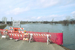
The Red River of the North Basin has a long history of flooding. Flooding typically occurs between the months of March, April and May.
Because of the relatively flat slope of this North Dakota river valley, the flow of the Red River is slow, allowing runoff to backfill into tributaries, particularly when the downstream river channel remains frozen. In addition, localized ice jams, may impede the water flow, resulting in higher river levels.
Breaking News 2009 Red River Valley Flooding

9APR2009 The National Weather Service said there is a good chance the river will crest again between April 15 and April 22
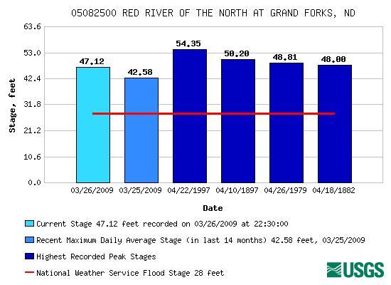
29MAR2009 The Red River crested at almost 41 feet last Saturday, breaking a record set in 1897.
24MAR2009 More than 600,000 homes are threatened and a massive sandbagging effort is currently underway. "We're diking where we've never diked before," Fargo City Engineer Mark Bittner said. The U.S. Army Corps of Engineers St. Paul District has issued more than 2.3 million sand bags and 310 rolls of polyurethane, and loaned more than 10 pumps to counties and cities in North Dakota and Minnesota.
Significant spring flooding is expected across the Red River Valley. Probabilities indicate that a majority of the river forecast points are expected to experience moderate to major flooding. For Example...the Red River at Fargo has a 98% chance of reaching major flood stage. The Red River at Wahpeton has a 98% chance of reaching moderate flood stage...and a 67% chance of reaching major flood stage. The Red River at Grand Forks has a 98% chance of reaching moderate flood stage...and a 72% chance of reaching major flood stage.
The magnitude of the expected flooding has not been seen in several years. At many of the locations across the Red River basin residents should be preparing for the threat of major and near record flooding. Also, significant overland flooding is likely for points not near a river.
Geography of the Red River Valley
The Red River Basin is unique because the mainstem of the Red River flows north into Canada and eventually into Hudson Bay. Consequently, the spring melt, and the eventual runoff, differs from many other areas of our county. (as a side note, the Red River is not the only river in the United States which flows north, there are others such as the Genesee River in Upstate New York). In a typical spring thaw, warmest temperatures and initial runoff begin in the source region of the Red River, over Northeast South Dakota and West Central Minnesota. After this runoff enters Lake Traverse it begins to travel north. Weather conditions farther north or downstream, however, are usually quite different from those of the headwater region, with melting and runoff yet to begin.
Weather Factors
Existing conditions must be considered when determining the magnitude of a spring flood. The main conditions include:
- The freeze/melt cycle
- Early spring rains which increase melting of the snow pack or late spring snow storms adding to the existing snow pack
- The actual snow pack depth and water equivalency
- Frost depth
- Soil moisture content
- River ice conditions
Some of these conditions are known in advance such as frost depth, soil moisture content, and river ice conditions. However, the most critical conditions, the first three mentioned on the list, are not fully known until just before or during the spring thaw. A typical spring thaw occurs from the middle of March across southern portions of the basin and mid or late April across the north.
Naturally, great variability in conditions can exists prior to the spring melt and runoff period. For example, temperature, and precipitation amounts can vary greatly. By considering all the factors, there are numerous scenarios which may or may not cause flooding in the Red River Basin. Snow depth is just one of those factors. To illustrate let's look at two different years in Fargo. One event caused significant flooding and the other did not..
The Spring Thaw of 1994 - The Major Flood That Wasn't
The winter of 1993-1994 established a previous record snowfall at Fargo with 89.1 inches. With a record snowfall, one could certainly understand concerns about a possible significant flood that spring. Snow depth during the month of February ranged from 12 to 24 inches with a 15 inch snow depth heading into March. Water equivalency from the snowpack at peak depth ranged from 3 to 4 inches of water. Precipitation in February and March was normal with nearly an inch of precipitation in March.
The key to the spring flood that year was an ideal snowmelt scenario. Daytime high temperatures during the Month of March and into April were greater than 32 degrees on all but 5 days which allowed a gradual snow melt. During this period, daytime highs generally ranged from 35 to 45 degrees with five days at or greater than 50 degrees. Also important was that nighttime lows fell below 32 degrees on all but five days during March. This cooling allowed snow to freeze at night slowing down melting and runoff which occurred during the day. As a result of the ideal melt, the Red River crested in Fargo on April 3rd at a stage of 26.70 ft. Although flood stage in Fargo is 17.0 feet this was considered a minor to slightly moderate flood. Far less than what one would expect with a record snowfall. Farther downstream on the Red, Grand Forks crested at 33.09 feet again, a relatively minor flood.
The Thaw of 1996 - A Different Outcome
Different results occurred following the winter of 1995-1996. Snowfall was again heavy, 74.6 inches, which was the fourth snowiest on record. A mild February dropped snow depths from nearly two feet at the beginning of the month to less than a foot going into March. Mild conditions again occurred the second week in March dropping the snow depth to a trace! This series of weather events seemed to temporarily eased concerns for any significant spring flooding. However, a cool down occurred the second half of March into the first week in April which stalled melting of the remaining snow cover and ensuing runoff. From the 16th of March to the eighth of April temperatures failed to reached 40 degrees and climbed above 32 degrees less than 40% of the period. A series of precipitation events raised snow depths up to eight inches going into April.
Starting on April 8th temperatures soared, ranging from the middle 40s to middle 60s across the entire basin. These warm temperatures melted the remaining snow pack in a matter of a few days, which caused a rapid runoff. Since this melting occurred relatively late in the spring melt period, rapid runoff occurred across the whole basin. As a result of the rapid warming late in the spring melt season, moderate to major flooding occurred over a large portion of the basin. Fargo crested on the 16th of April at 28.73 ft. which caused moderate flooding. Grand Forks crested at a stage of 45.82 ft. which caused significant flooding. Significant flooding was observed at Drayton, Pembina and Winnipeg as well.
The Great Flood of 1897
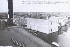
Because the 1897 flood is often used as a measure of other Red River Valley floods, a description of it at Fargo and Grand Forks was included in a 1952 U.S. Geological Survey Water Supply Paper. Text from that description is reprinted below.
The winter preceding the great 1897 flood was extremely severe as shown by the following remarks from the Fargo Forum and Daily Republican for March 15, 1897, under the heading "The Coming Flood":
The present indications are that we will have high water this spring, as high if not higher, than it was in the spring of 1861. If all reports are true there is more snow on the level now than there was in the spring of 1861. That year the entire valley was flooded from Big Stone Lake to Winnipeg, a distance of more than 300 miles. There are but four men living in the valley now that witnessed the great flood of '61 -- the largest body of fresh water in the world at that time * * * R. M. Probesfield is authority for saying that he, a few days ago, measured the snow in his timber, where it was free from drifting and it measured 5 feet. This measurement is two and one-half feet more snow than we had in 1861. Those facts prove that we will have a greater flood this year than in the history of the valley. Old Settler.
The flood forecast by "Old Settler" was not long delayed. The Red crested at Wahpeton on March 31, 2' 8" above the 1893 high. By April 1, 1897, the C. M. St. P. & P. Railway tracks between Fargo and Wahpeton were covered with water in spots and traffic was suspended. By April 2 the Buffalo River overflowed so a large lake was formed between Glyndon and Moorhead. The Wild Rice (N. Dak.) River was described as 'on a splurge too'. The Sheyenne River was reported rising slowly at Valley City on April 3. The Red crested early on the morning of April 7 at Fargo at 34.2 foot stage (present [1952] datum) exceeding the known high levels of 1871, 1873, and 1882. The Sheyenne River, by April 8, was up so high that water flowed overland from it to the Wild Rice River. The flood of 1897 at Fargo covered most of the business and residential areas of the city.
The 1897 flood crested at Grand Forks about noon on April 10 bringing the water up to a line along Third Street and covering Demers Ave. in East Grand Forks. Flooding on all tributaries between Grand Forks and Emerson was reported, and a serious situation developed at Grafton. The crest reached Emerson [Manitoba] on April 24 and completely flooded the town. The flood of Winnipeg [Manitoba] did not receive mention as an outstanding event.
Related Articles