Flowers of Marengo
1903 Map
Perspective Map
Click below the adjacent image to see an larger copy of the Washington Revitalization area from a "Bird's Eye View".
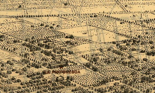
This Map shows what our area looked like in 1903. It is not a photograph, it is a drawn map.
This section was "clipped" from a Map of Pasadena.
Here is a link to the web site for seeing other parts of Pasadena:
Historic Pasadena Map
Monk's Hill
As you look at the map, notice the La Pinoresoa Hotel. This is the location where the La Pinoresca Library and Park are presently located, bounded by Fair Oaks Ave on the left, Washington Boulevard on the South, and Raymond Avenue to the Right. The next Major Street to the Right is Marengo Avenue, and you can see that it climbs the Monk's Hill, and goes all the way up to Woodbury (The diagonal street near the top). Where the "hill" is, you will note an empty lot area to the left of Marengo and North of Grand View (the first street above Washington). This is the present location of the Washington Middle School.
You will also note Grace United Methodist Church on Washington Boulevard and Iowa St (the small street to the right of Raymond)
Posted
by flowers on 09/09/2000

- Advertise Here!
-
Promote Your Business or Product for $10/mo

For just $10/mo you can promote your business or product directly to nearby residents. Buy 12 months and save 50%!
