Pacific Beach Community Planning Committee
Our Information
- Contact List
- Our contact information...
- Newsletter Archive
- Post Your Newsletter
About Us
Pacific Beach Community Planning Committee
na
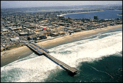
The Pacific Beach
Community Planning Area
The Pacific Beach community planning area is located within the mid-coastal region of the City of San Diego. It is bounded on the north by La Jolla, on the east by Interstate 5 and Clairemont Mesa, on the south by Mission Bay Park and Mission Beach, and on the west by the Pacific Ocean.
Development and Planning History
Pacific Beach was included within the oringinal Pueblo Lands, which divided the area into a large grid pattern in the mid-1800's. The founding of San Diego College of Letters at the northwest corner of Garnet Ave and Lamont St. in 1887, acted as a catalyst for development of a nearby small village. In 1910, the redevelopment of the college site to the San Deigo Army and Navy Acadamey (later named Brown Military Academy) spurred significant residential building activity.
This activity continued at an accelerated pace through the war and post-war years. During this same period, major transportation routes served as the focal points for commercial development. With the exception of Pacific Plaza, very little change has occurred to the commercial development pattern established at the time.
Tourism has consistently had a major economic impact on Pacific Beach and its surrounding communities. Belmont Park, Crystal Pier and Mission Bay Park were all developed to take advantage of this potential.
The Mission-Pacific Beach Community Plan, adopted by the City Council in 1970, was the first area plan for Pacific Beach. In 1974, the Council adopted the Mission Beach Precise Plan, and amended the 1970 plan to remove the Mission Beach Planning Area.
In 1977, the City Council recognized the Pacific Beach Community Planning Committee as the official organization to provide citizen input on planning and development issues in Pacific Beach. The committee worked with the Planning Department to prepare the updated Pacific Beach Community Plan and Local Coastal Program Land Use Plan, which was adopted by the City Council in 1983. The plan has been amended five times since then.
In 1988 and 1989, the City Council approved rezonings to various residential and commercial properties in Pacific Beach to implement the 1983 community plan and the local coastal program. Upon the California Coastal Commission's certification of these rezonings in 1988, the City assumed Coastal Development Permit authority for most of the properties within Pacific Beach's coastal zone.
In 1990, as part of the City's Single-Family Protection Progam, the 1983 plan was amended to redesignate most of the community's multifamily residential area from a maximum allowable density of 29 dwelling units per acre to a maximum allowable density of 15 dwelling units per acre, with rezonings from R-1500 to R-3000. This latest downzoning followed previous downzonings in the community from R-1000 to R-1500 in the 1980's, and from R-400 to R-1000 prior to that.
Local Coastal Area
The California Coastal Act of 1976 established a coastal zone boundary and mandated that all jurisdictions within that boundary prepare a Local Coastal Program (LCP). The LCP brings the jurisdiction's planning process into conformance with the 1976 Coastal Act.
na
na

- Advertise Here!
-
Promote Your Business or Product for $10/mo

For just $10/mo you can promote your business or product directly to nearby residents. Buy 12 months and save 50%!
