Heninger Park
Our Information
- Contact List
- Our contact information...
- Newsletter Archive
- Previous Newsletters...
About Us
Heninger Park

HISTORY OF HENINGER PARK
This old POSTCARD of Heninger Park shows the 600 block of S. Birch Street. The view is looking toward the Heninger House. The Heninger House is located on the SW corner of S. Birch St. & Bishop St.
MARTIN R.HENINGER
Martin R. Heninger came to Santa Ana on May 15, 1906 to join his brother, H. B. Heninger who had been in Santa Ana since 1903. Together, the brothers were instrumental in the development of the southern section of the city of Santa Ana.
Martin Heninger was born on November 29, 1851 in Monroe County, Missouri. He grew up on his parents Eliza J. (Stalcup) and William W. Heninge's farmr. When he was seventeen years old his father died and Martin left school to assist in caring for his mother and his seven
brothers and sisters. He remained on the farm until 1882.
On July 9, 1882 Martin Heninger married Mary A. Way. He and his bride moved to Dakota Territory. Martin worked in the retail lumber business in Ordway, now South Dakota. After a year they moved to Wesport where he spent the next twenty years. Mr. Heninger became one of the town’s most substantial business men. He worked in the banking exchange business and owned a farm 450 acre farm. After selling his assets Mr. Heninger then moved to Aberdeen where he bought a third interest in the Aberdeen Electric Light and Gas Company. He lived in Aberdeen until 1906.
Mr. Heninger’s father had been a Republican and Union man during the Civil War. Martin Heninger also had an allegiance to the Republican party. During the many years of Mr. Heninger’s residence in South Dakota he was very prominent in Republican politics and in the public life of the State. He was a member of the Constitutional Convention held at Sioux Falls which acted in the admission of South Dakota to statehood in 1889. He was also elected clerk of Brown County in 1895 and served for two years. He was a Mason and was also with the Ancient Order of United Workmen and the Modern Woodmen of America.
After selling his interest in the Aberdeen Electric Light and Gas Company Mr. Heninger left South Dakota and moved to Santa Ana, California. In 1907 Martin Heninger and his brother bought thirty-four acres of land, now called Heninger Park, from of the Noah Palmer Ranch. When Mr. Heninger purchased this property it was a barley field. The following year a combined harvester was at work on the property, cutting, threshing and sacking the barley. They developed this tract planting trees, putting in sidewalks and curbs. Later they bought additional tracts, one of ten and one of eighteen acres which they planted and improved. These properties are known as Heninger Additions 1, 2, 3, and 4. Many miles of street paving, sidewalks and curbs were put in with $10,000.00 spent for street paving in one year alone.
Mr. Heninger and his brother developed most of Heninger Park, selling lots and building houses for their clients. Over a period of twelve years they built 150 homes on the property. At end of the 1920’s most of the lots were built up. By 1922 Heninger Park was said to be the finest residence section of the City.
The first Heninger family home was on S. Broadway. The second Heninger family home is located on S. Birch. This large, two story Colonial Revival style house with a wrap-around porch was their dream home. It was built on two lots with a sweeping front lawn. Martin and Mary Heninger lived here with their three daughters, Nora, Mabel and Mildred.
The third Heninger family home is located on 714 S. Ross. Mr. Heninger lived here until his death on April 1, 1922. He is buired in Fairhaven Memorial Park. His grave site and marker can be found at Lawn K, Lot 60.
During Martin Heninger years in the Santa Ana no one had been more active in the development of the southern section of the City. He had transformed a barley field by planting trees, putting in sidewalks and curbs and well built, beautiful homes. Today it is called Historic Heninger Park, and known as Santa Ana's Bungalow Neighborhood.
About our association
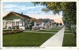
600 block of S. Birch Street
This old POSTCARD of Heninger Park shows the 600 block of S. Birch Street. The view is looking toward the Heninger House. The Heninger House is located on the SW corner of S. Birch St. & Bishop St.
History of Heninger Park Neigborhood Movement
Early in the 1980's a movement to preserve and restore the neighborhood was organized. Known as the "Birch Street Citizens for a Better Neighborhood" this group worked with City Staff to find solutions for neighborhood preservation. Long time residents and new comers alike had rediscovered the unique character and quality craftsmanship of Heninger Park's Craftsman Bungalows. Residents were alarmed by the increasing trend in the City to allow the demolition of bungalows to make way for the construction of large apartment buildings. Fearing the demise
of the character of the neighborhood as the knew it and grieving the loss
of irreplaceable architecturally significant Craftsman Bungalows residents met to discuss the future of their neighborhood and make plans
for it's preservation.
Residents felt that the architectural and historical character of the houses, churches, schools, commercial buildings and neighborhood markets were one of the neighborhoods most important features. They decided to ask the City Council to designate Heninger Park area as a local historic district.
Preliminary work was done before bringing their request to the City Council. A systematic block-by-block, house-by-house historic resources survey was conducted. The study area was bounded on the north by West Camile,
on the south by West McFadden, on the east by the alley behind Sycamore Street and on the west by South Flower Street. This was the area
designated for study by City Staff.
The survey methodology included photography, mapping. architectural descriptions and historical research. A black-and-white photograph was taken of each building . Slides of many of the houses and buildings were taken to illustrate a permanent slide show about the future Heninger Park Historic District. Maps were prepared to illustrate four different types
of information including, contributing buildings and non-contributing buildings. A brief paragraph was written describing the architectural style and details of each building and its contributive status. Each house was researched for historical significance in old city directories. This information included the year of construction, first owner's name and the name of subsequent owners, occupation and place of employment of the people and any children listed who had lived in the house. This amounted to a file on approximately 4000 persons who lived in Heninger Park neighborhood during its developing years.
In May of 1986, the residents of homes in Heninger Park went to the City Council to request that their neighborhood be designated as Santa Ana's second local historic district. Based on information presented by the neighborhood organization and City staff, the City Council officially created the Heninger Park Historic District as a special historic overlay zone. The language of the ordinance set standards for the restoration and revitalization of the exterior features of all properties. It was given the official designation Specific Development No. 40 or SD-40. The boundaries are First Street on the north, West McFadden Avenue on the south, South Flower Street on the on the west and South Sycamore Street on the east. The district is known as Santa Ana's Bungalow Neighborhood because its many Craftsman Bungalows.

- Advertise Here!
-
Promote Your Business or Product for $10/mo

For just $10/mo you can promote your business or product directly to nearby residents. Buy 12 months and save 50%!
