Brentwood Community Council
Our Information
- Contact List
- Our contact information...
- Newsletter Archive
- Previous Newsletters...
About Us
Brentwood Community Council - official site at www.brentwoodcommunitycouncil.org
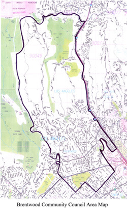
BCC Boundaries - Expanded Description
Mulholland Drive is the northern boundary, from its origin to the west of state owned lands, to the west side of the San Diego Freeway on the east.
The eastern boundary follows the freeway to the north side of Wilshire Boulevard, excluding the property owned by the federal government and administered by the Department of Veterans Affairs.
The southern boundary is the north side of Wilshire Boulevard from its intersection with San Vicente Boulevard on the east, to the east side of Centinela Ave., north on Centinela to Montana, west on Montana to the east side of 26th Street on the west.
The western boundary is 26th Street north from Montana, continuing just west of and along Rockingham Avenue (including Paul Revere Middle School*), north along Sunset Boulevard to Old Ranch Road, including the complex of streets north of Sunset known as Riviera Ranch Road, Old Oak Road and Old Oak Lane, then continuing along the eastern edge of lands owned by the State of California, known generally as Topanga State Park. *Paul Revere Middle School is shared with the Pacific Palisades Community Council.

- Advertise Here!
-
Promote Your Business or Product for $10/mo

For just $10/mo you can promote your business or product directly to nearby residents. Buy 12 months and save 50%!
